I have never followed the River Tone between Taunton and Wellington and the 1:50000 OS map shows that there are footpaths along the route which is called the West Deane Way. Following a wet spell. the weather looked fair for a few hours so it was a spontaneous idea to walk to Wellington and return by bus.
View Taunton to Bradford on Tone in a larger map
I actually started near the railway station in a place where I can park for free. I headed through town to the bus station, nearly a mile away, to check the bus times. Taunton has some good points but the town centre always fails to inspire me. The negative feeling was compounded by a sign on the enquiry/ticket office door to say "Closed today due to sickness". However, I did find a timetable for buses TO Wellington and buses were every 20 minutes. There was a total absence of information about when they returned but it seemed only slightly dangerous to assume that this would be at the same frequency!
The first part of the Walk was spoiled by construction work on Taunton's "third way". The normal riverside walk was closed so I had to make my way through car parks and past the Tesco supermarket before arriving at Firepool Wier. There was a great deal of water going over the wier due to the previous day's heavy rain. I crossed the footbridge over the wier to the north bank of the River Tone. From here the path follows the River Tone with Taunton's suburbia just to the north. However, a point of interest is the formation of the Parliamentary Cut. This was a short length of canal linking the Grand Western Canal to the River Tone. Its remains can be seen in the forms a linear depression yards to the north of the path. The Grand Western Canal ran from Taunton to Tiverton and is still navigable at the western end but long devoid of water near Taunton.
Further along. the path leaves the side of the river and crosses a new "country park" before leading past the park and ride off Silk Mills road. A small artificial lake has been created in this area.
 |
| Artificial lake at Roughmoor |
 |
| Young trees (foreground) at Netherclay. |
 |
| A ballast train heading onto the West Somerset Railway |
Norton Fitzwarren is also a railway junction. Today the preserved West Somerset Railway, running to Minehead, still diverges from the main line to the west of England. The WSR is constucting a triangle of track near the junction to allow trains to be reversed. A spin-off from this is that a site is provided by the WSR for the disposal of used ballast recovered from relaying the main line. A special train runs onto the WSR and deposits the ballast which is then recycled. Prior to the railway closures of the 1960s a line to Barnstaple also diverged from the main line here. Track has now been relaid on the first part of this and forms one side of the WSR's triangle
The path ran through pleasant enough, but rather soggy meadows close to the River Tone and crosses Victory Lane. Just before the Village of Bradford on Tone there is a wier and soon after that I arrived at the 14th century bridge just to the south of the village. At this point I had taken longer than expected and had quite sore feet. I therefore decided to walk to the main road and get the bus back to Taunton.
 |
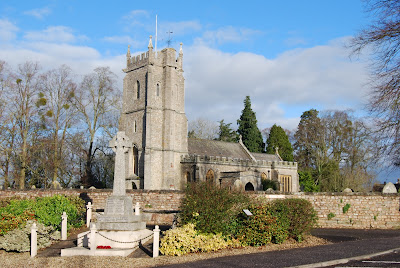
| Bradford on Tone church and war memorial |