Welcome

This blog is intended to record the walks that I take before I forget the detail. These walks are not necessarily long or spectacular but I hope others will enjoy the blog.

I usually carry a camera and have started some Picasa web albums so that others can share the photos I take and comment on them if they like. Follow the link to my public albums

I hope you find the blog and the photos interesting.

A note on maps: I have started to embed Google Maps into some postings. These should add value by giving an idea of the locality of the walks. I have done my best to plot my tracks using the Google satellite view, but please take these as indicative rather than authorative. I would recommend carrying Ordnance Survey 1: 25000 maps when walking off roads in the UK.
Showing posts with label Walking. Show all posts

Sunday, 17 April 2011

Stogumber Station to Bishop's Lydeard Station via the Quantocks 12 April 2011


View Stogumber station to Bishop's Lydeard in a larger map

This was the longest walk I have undertaken for some time. It was 9.5 miles in length and took me 4.5 hours. I did not use the car, setting out from home and returning from Bishop's Lydeard by steam train on the preserved West Somerset Railway.

I have embedded the above Google map. This shows the route of the walk, but should be taken as indicative rather than authorative. For walking I recommend the use of paper 1:25000 Ordnance Survey maps. These show, for their date of publication, public rights of way and field boundaries, although both are subject to change. There are digital options but I have not used them.

The morning was a little chilly but it warmed up when the sun got higher. The day was mainly sunny with white cumulus clouds and a fairly strong breeze in exposed places. Visibility was fairly good and I decided that I would use my longer focus zoom lens and leave the standard one at home . I took an old 1980 Ordnance Survey 1:25000 map, Sheet 03/13. These were a smaller and far easier to handle out of doors than the current Explorer series but rights of way do change.

The first 1.5 miles were on the lane running from Stogumber station to the A358, the main road from Taunton to Williton. Stogumber station is actually in the parish of Crowcombe rather than Stogumber, but only just. The two place names were immortalised by Monty Python's Flying Circus

Having crossed the main road, I walked towards the centre of Crowcombe. After a couple of hundred yards I found to my left, opposite a thatched cottage,  steps leading to a path that gives access to the Quantock Hills. Having passed a garden and some chickens the path leads into  open pasture and continues uphill towards the open moorland. On this part of the route a couple of dodgy and difficult stiles have recently been replaced by new wooden gates. The fields had particularly pleasant spring green colour to them and trees were just coming into leaf.
 View from the meadows above Crowcombe

The path is not distinct here but you simply follow the signs with the Crowcombe estate woodland to the right and eventually come to the gate leading into the open country. There were none today, but I have seen deer in this area.

A narrow path then led through the heather and gorse, climbing again before levelling out somewhat and bearing right to join the track leading to Crowcombe Park Gate and eventually crossing the Crowcombe to Nether Stowey road.
The well trodden, old Quantock ridge road continues between trees. You cannot really see much from this road because of the trees and banks on either side, but at one point it was possible to get a view to the north east accross Bridgwater bay As soon as possible, in order to get better views to the west, I opted to use a gate that gave access to the open country above the steep, western, combe indented slopes of the hills. Trees are OK but too many make me feel penned up, so I was glad to get onto the open country. The prominence named Great Hill on the 1: 25000 map  is less wild than most of the Quantock ridge. It consists of open grassland with patches of gorse and trees. Before long there was a clear view of Wills Neck, the highest point on the Quantocks at 384 metres above the OS datum. It is also a Marilyn.
View of Triscombe quarry and Wills Neck from Great Hill
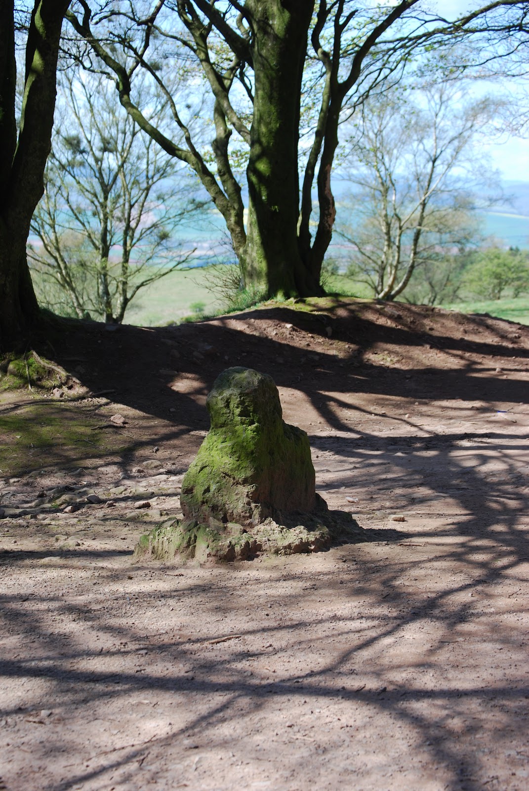
The next point of interest is the Triscombe stone. This is found at the junction of the ridge road, the track that climbs steeply past Triscombe quarry and the tarmac road that runs up Cockercombe giving road access from Nether Stowey and Bridgwater. It is not a spectacular monument, being only about 60 cm high, but it is thought to date back to the Bronze age. I have since found that there is an interpretation board about the Triscombe stone but I did not see it. I can believe its significance as the Quantock ridge route was an old drovers' road that in its day must have been important. There is a car park here and there were a few people enjoying the fine weather.

From the Triscombe stone, there is an easy climb to the summit of Wills Neck. As could be expected there were good all round views from here. The Ordnance Survey triangulation pillar here is part of their GPS network. Follow this link to an informative web site about trig pillars. It seems that they have their own enthusiasts.

It was too breezy to stop for lunch on Wills Neck, so I continued to the edge of the woodland above West Bagborough. There is a large depression here that contains a pond. The OS map contains the legend "Pits (disused)". So far I have not been able to determine what these pits, which I am sure are man-made, were used for.
The triangulation pillar on Wills Neck with Hinkley Point power station behind
Looking from near Wills Neck towards Minehead


After eating my packed lunch I continued along the ridge track before taking a left turn onto a track that descends steeply and leads directly to The Rising Sun pub in West Bagborough. The georgian Bagborough house is to the right of the track and a good view of it was available at one point.

Bagborough House
Most of the route to Bishop's Lydeard was on quiet country lanes across the lower countryside with a short stretch on a bridleway. I arrived at the station in good time to catch the 1605 train back to Stogumber.

While waiting for the train I noticed some old buses stored in a barn to the west of the station. I has not spotted these before assume that these belong to Quantock Motor Services Ltd. This company owns and runs a number of restored heritage buses as well as a more modern fleet. It has its depot right next to the station Most of the vehicles I could see in the barn looked to be in unrestored condition.


This had been a very enjoyable walk on a beautiful spring day but I was pleased to take my seat on the train for the journey back.
Buses stored near Bishop's Lydeard station

Monday, 7 March 2011

The Hangmen 3 March 2011

This was a 5 mile circular walk starting from Combe Martin in Devon. Including stops for lunch and photos it took me 2.5 hours.


View Combe Martin and the Hangmen in a larger map

At home in Stogumber we were greeted by early morning sunshine but on the way to Exmoor I ran into cold cloudy weather. The Met Office's current observations web page had shown  that sunshine lay to the west. This was borne out when I crossed the Somerset/Devon border. I was in continous sunshine until I travelled home, although it was rather hazy. It was also considerably warmer in Devon.

I followed the coast path leading east from Combe Martin. The path climbs  fairly steeply to Lester Cliff and beyond the part where it is edged by low trees there are good views back to Combe Martin and down to Wild Pear Beach.
Wild Pear Beach
 It is possible to access the beach from the Coast Path but the way down is not obvious and I did not spot it. Wild Pear beach is apparently frequented by naturists, but, I do not think they were around on this day.

 It did not take long the reach the summit of the Little Hangman. At 218 metres, this summit is 100 metres lower than the Great Hangman, but it is, in some ways, a more distinctive topographic feature. I have had a quick look around the Web to see if I could find out how these features got their names but I found nothing that could be substantiated.

This area is the type locality of the Hangman Grits which form much of the highlands of Exmoor and are exposed along the rugged coastline. The also form part of the Quantock Hills.
The view westward from Little Hangman
Little Hangman from the east. The Hangman Grits dip steeply to the north.
There is a deep cleft just to the east of Little Hangman and the rocks are well exposed. There is a gentle ascent from Little Hangman before the final climb to the cairn on the summit of Great Hangman. As you might expect, there are good views all round from this vicinity. To the seaward of Great Hangman there is a steep drop of 244 metres to the foreshore. This is the highest coastal cliff face in England. It would have be seen from the sea to really appreciate it.

Great Hangman from Little Hamgman

I would have liked to carry on along the coast towards Hunters Inn, which was only about 4.5 miles away, but I think getting back to Combe Martin by public transport would have been  problem. I took a path marked "Country Road" that headed south after leaving the open country and crossing a couple of fields the path became a concrete track leading into Girt Lane. Shortly after passing a house, I turned right into Knap Down lane. This is a well defined path that gives a direct route back to Combe Martin. From the lane there is a fine view across a valley towards Little Hangman.
Little Hangman from Knap Down Lane
The area around Combe Martin has a history of mining. In particular, silver was mined form the Middle Ages and the 1800s, but other metals, such as iron and zinc have also been extracteded.

This was an interesting walk on a day when Spring seemed to be properly on the way in North Devon if not in West Somerset.

Sunday, 10 October 2010

Minehead to Porlock via the rugged coast path 7 October 2010

Distance - 8 miles
Time taken - 4 hours 30 minutes

It was a beautiful morning and the forecast was promising. I last did the "rugged" part of this route in December 2008 and have since had an ambition to walk from Minehead to Porlock and return by bus. So, off I went.


View Rugged coast path in a larger map


I left Minehead on the normal South West Coast Path. I was surprised to see that path had been visited by the guys who paint around potholes, so that months later, if the paint has not worn off, someone with a bucket of tar, fills them in in. This has struck me as being a wasteful process as it would surely be more efficient to send the tar out in the first place. This example should win a prize. It was not even a particularly deep hole.
Pothole?
I followed the track towards Greenaleigh Farm. This part of the route is wooded and there is only one place where you can look down and see Minehead Harbour. Trees are great, but I like to see out.
The path diverted from the track to the farm and went gently uphill. The trees eventually thinned out to give coastal views back towards Minehead.
Greenaleigh Point

The rugged alternative coast path is clearly signed where it diverts from the standard route.
The rugged path follows the coast around the area of pasture on North Hill. I think it is a much more interesting route than the standard path. It is the true coast path, having the essential quality of sea views. Today these were excellent, although it was a bit hazy. The route certainly involves more ups and downs and is harder work, but is not particularly difficult if you are reasonably fit. It is longer as a result of heading up into and out of several deep valleys (Combes).
Grexy Combe
To begin I had to descend into Grexy Combe and then climb back to the top of the cliff beyond.The next section is mostly easy, following a straight section of coast, although there was a short section where the path was eroding quite seriously above a steep drop. Near here I came across the biggest caterpillar I have ever seen.

A big caterpillar
I do not know what sort of moth or butterfly this will turn into but I think Air Traffic Control need to be informed. A couple I met had seen an adder.
At the end of a straight section a came to a point where the path turned south to go around Henners Combe. This was a good place to eat lunch as there were some rocks that made a dry place to sit down.At this point a good view of the coast to the west is revealed. Foreland Point was clearly visible. As it  was low tide I also had a glimpse of Selworthy Sand from here.

Looking West over Henners Combe
 The next section of the route headed along the eastern side of Henners Combe before crossing the two streams and then climbing up the western side. It was not far beyond this that the process was repeated to cross East Combe. There are better views of Selworthy Sand from here. The only way I know onto this beach involves using a knotted rope for support to get down the steep slope, consisting of loose rock, that is found at the back of the beack. The rope is tied at its upper end around a boulder. I have not dared try this.
Looking down on Selworthy Sand

After East Combe I followed the track to the top of Hurlstone Combe. I found that descending the steep path down the Combe was the most tiring part of the whole walk. Still there was no more serious climbing to do. I just had to follow the track to Bossington and along the lane to Porlock in time for the 15:23  No 39 bus back to Minehead.

This was a very  satisfying walk on a beautiful day surrounded by wonderful scenery


Wednesday, 22 September 2010

The Quantocks 21 September 2010


This was a 6 mile walk that took me about 2.5 hours. The weather was warm with periods of sunshine, but rather hazy.

I do not have a GPS set but do like to carry a decent map. In this case it was Ordnance Survey 1:25000 Explorer Map 140 "Quantock Hills and Bridgwater". These are the best maps available, but the Quantocks are cris-crossed by a network of paths and tracks in the access land that have no official status and are not mapped. This can be confusing at times. Also, it seems to me that the boundaries between woodland, scrub and heath are not always in the right place. The map I have was revised in 2004, but I do not think this included the vegetation information. The land forms do not change much but bushes and trees can grow considerably over a couple of decades. or be removed quickly.

Back to the walk.

Starting from Staple Plain I followed the Great Road . This stony track, not a public road or particularly great , has a sign at the start saying "No unauthorised vehicles". There are often vehicles on it in quite large numbers. I wonder how many of them are authorised? How do you tell? Today however, it was quiet.

The Great Road offered excellent views towards Minehead, the Brendon Hills and Exmoor before crossing the Quantock ridge, and equally stunning views over the Bristol Channel, Sedgemoor and the Mendips on the Holford side. For an excellent all round view it is only a short detour to the summit of Beacon Hill. The track eventually leads to the edge of the woods above Holford. Here there are a plethora of paths but I found no signs pointing to Holford. One that led downhill and in the right general direction came out on a sharp corner of the drive that leads to Alfoxton Park. On this corner there is a very substantial rectangular stone walled, roofless structure. There is a plaque on the wall that reads:

"This ancient dog pound was given to the village of Holford in l982 by the family of the late John Lancelot Brereton, descendants of St Albyn's owners of Alfoxton
since the 15th century whose crest appears above."

Unusually, I did not have a camera with me but there is a photo and a rather grisly explanation on the Quantock Online website. The structure also shows up clearly on Google Earth. I did wonder whether one of John Lancelot Brereton's ancestors was a Member of Parliament who claimed expenses for building this!

At this point I joined the route of the Coleridge way. The drive leads through woodland to Alfoxton House. This is marked "Hotel" on the map but there is no evidence on the ground to suggest it still serves this purpose. William Wordsworth and his sister Dorothy stayed here in 1798/9 and spent time with Coleridge. The route passes behind the house, and after passing Alfoxton Cottage turned right and led downhill . I preferred to keep to higher ground and found one of those unmapped paths that took me back to the Coleridge Way without losing height. I crossed Dene Combe, with its unmapped but unmissable narrow strip of woodland, before cutting up another narrow path to meet the Greenway path (not to be confused with the Quantock Greenway). This went steadily but not too arduously uphill and offered a view of pleasantly empty moorland ahead and fine views over the Bristol Channel, Kilve and East Quantoxhead behind. The Greenway Path joined the Great Road which I took back to Staple Plain.

This was a satisfying walk covering some new ground as well as parts I have visited before.

Monday, 20 September 2010

Chrome Hill - The Peak District


In younger days I spent a fair amount of time in the Peak District.

From the A 53 road that runs between Buxton and Leek, if you look east, you can see some limestone hills that are distinctively jagged, at least for the Peak District. These are Chrome Hill and Parkhouse Hill.

These intrigued me but I had not managed to investigate them properly until the 4th September this year. I was on the way back to Somerset from a funeral in Salford and decided to take the time to climb Chrome Hill and visit the Churnet Valley Railway, just south of Leek.

I could not resist taking the scenic route through Pott Shrigley and past the Cat and Fiddle pub I arrived in the village of Hollinsclough.

I parked in the gap between Chrome Hill and Parkhouse Hill and set off up the ridge of Chrome Hill. This was not a long or hard walk, about half a mile each way but does offer spendid views in all directions. Iwould have liked to try Parkhouse Hill with its steeper ridge and strange conical formations but the Churnet Valley Railway beckoned.

More pictures