Welcome

This blog is intended to record the walks that I take before I forget the detail. These walks are not necessarily long or spectacular but I hope others will enjoy the blog.

I usually carry a camera and have started some Picasa web albums so that others can share the photos I take and comment on them if they like. Follow the link to my public albums

I hope you find the blog and the photos interesting.

A note on maps: I have started to embed Google Maps into some postings. These should add value by giving an idea of the locality of the walks. I have done my best to plot my tracks using the Google satellite view, but please take these as indicative rather than authorative. I would recommend carrying Ordnance Survey 1: 25000 maps when walking off roads in the UK.

Sunday, 27 May 2012

The Doone Valley 23 May 2012


View The Doone Valley 23 May 2012 in a larger map
This was my first walk following a period of generally atrocious weather in April and the first half of May.

The morning was misty but the sun came through when I reached the top of Porlock Hill and the temperature started to climb.

The feature known as "The Doone Valley" and the surrounding area  is the inspiration and setting for R D Blackmore's romantic novel Lorna Doone. I have never read the book, but it is set in the 17th century and features a clan of outlaws who lived in the then remote valley. It seems less remote now. Its upper part does not have vehicular access but is a popular walking route and the fictional Doones would get plenty of visitors these days.

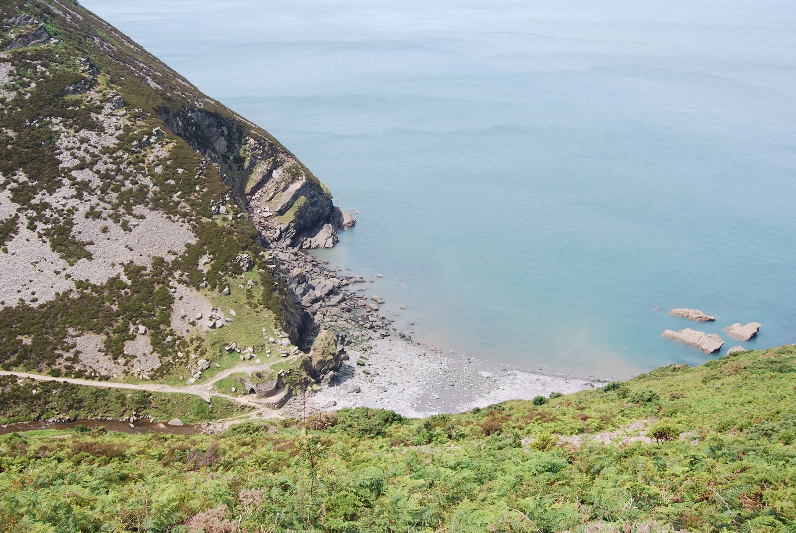
There is a car park at Malmsmead which costs £1.50 for the whole day. This hamlet lies at the entrance to the valley. Near here, Badgworthy (pronounced "badgery") Water, the river that flows down the north - south oriented Doone Valley joins Oare Water to become the west flowing East Lyn river. In the Doone Valley Badgworthy Water forms the boundary between the counties of Devon and Somerset.

From the car park I headed up a lane that is signed as the way to the public right of way up the Doone Valley. There is a private path that runs closer to the river in the lower part of the valley. The toll is 50 pence.

Badgworthy Water near Cloud Farm
Where the lane turned sharply to the right the public path continued straight on, The path descends to the river bank near Cloud Farm which has a camp site and a tea room. Beyond Cloud Farm there is no more habitation in the Doone Valley today. The water tumbles over rocks and has some quite deep pools .

A little further on there is a stone memorial to R D Blackmore whose novel, published in 1869, must have introduced Exmoor to many Victorians and today lends its title to many cafes, shops, hotels and so forth. A more modern example is Goathland, on the North Yorkshire Moors, which was the setting for the TV series "Heartbeat".

A good place for lunch
The path then entered  Badgworthy Wood. Oak was the predominant species and the trees were just coming into leaf.  It was time for lunch and I found a good spot by the river.  Continuing up the valley I came across a wooden structure built across the watercourse. This was a set of gates that were hinged so that they could open downstream. There were stock proof fences on the banks either side of the gate so I think the idea is to stop livestock using the shallow water to cross the boundary. The gates would open in times of flood to allow debris to pass downstream.  The temperature was rising by now and the shade provided by the trees was pleasant
Hinged gate
Beyond the woodland the valley became more open and the countryside started to take on an upland nature with scree slopes on the opposite side of the valley.
Badgworthy Water south of Badgworthy Wood 

 After a while my route started to climb above the level of the river and turned westward into Hoccombe Combe, a tributary valley. Other paths, including the long distance Samaritan's Way (south west) continue to the south.  Below the area where the paths diverge there are a number of grassy hummocks. These are all that remain of an abandoned medieval village. This remote settlement seems to have been in decline at least since the 15th century.

The next section of the walk climbed steadily, but not steeply, onto high moorland. Not far beyond the old village site I came across a herd of Devon Red cattle with several calves. As the name suggests, this hardy breed has a rich deep red-brown coloured coat.
Devon Red cattle 
On the moorland the path became rather indistinct and braided, but as visibility was good and the sun was out, I was able to keep heading in the right direction. Having grazed the 400 metre contour near Withycombe Ridge the path became more obvious as it descended to Lankcombe Ford where it crossed a tributary of Badgworthy Water. It then climbed back onto the high moor. I turned to head north onto a track that was signed to Malmsmead.
Open moorland
It was about half a mile further on that something went wrong and another half mile before I realised. According to the map Ordnance Survey OL9) I should have arrived at another ford but there was no sign of it. I had missed the point where the footpath left the made up track that I was walking on and had headed west rather than north. I came to a point where the track turned abruptly to the north - west and this would have brought me back onto my intended route. However, I decided to take a path that carried straight on and then follow a contour. This worked and brought me back to the lane on which I had started but further along. It was hard work as I had to climb into and out of a couple of deeply incised valleys.

It just remained to walk down the lane to Malmsmead to end what had been a very pleasant walk. My intended route had been 6 miles in length but, because of my error, I ended up covering 7.5 miles.

Wednesday, 4 January 2012

Hurlstone Point in squally weather 5th December 2011

The day was windy with a mixture of sunny spells and vicious showers of rain and hail. I was lucky and only endured one shower. Visibility was good between showers.


View Hurlstone Point in a larger map

The walk was about four miles and took me about two hours. I started from the car park above Bossington, at the end of the North Hill road out of Minehead. There is a network of possible walking routes from here, and although I have visited the area a few times I still managed to find sections I had not walked before.

From the car park I took an unsigned path that headed off in a north westerly direction rather than those signed to the Coast Path or Bossington. I then headed  west until I came to a stile crossing the wall on the edge of Bossington Woods. Looking to my right I could see below me a path heading down Lynch Combe and hoped to be able to meet this path at a lower level. I soon found myself heading south, and would have eventually arrived at Allerford if I continued this way. However, the path eventually slanted downhill to meet the more formally designated foot path that would take me to Hurlstone Point. The path leads down into Lynch Combe, crossing the track in the bottom of the combe before taking a short climb out of it again and more or less following the 100 metre contour to Hurlstone Point. Having been in woodland for some time with glimpses of the view across Porlock Bay, I was glad to get out into the open again.


The official guide to the South West Coast Path web pages describe a walk starting and ending at Bossington described as the  "Hurlstone Point Adventurous Walk". This includes a description of the next section.

In a westerly wind Hurlestone Point is about as exposed as you can get and there were some vicious gusts; but having been this way before, I passed the warning sign and continued cautiously. Although narrow and rather exposed the path is firm and even though I tend to suffer from vertigo where there is a real danger of falling and have never felt inclined to take up rock climbing, I felt reasonably safe.

The shell of a former look-out tower stands above the jagged headland which is composed of the tough Devonian Hangman Grits.
Hurlstone Point look-out station
The narrow path continued with rocks above and a steep grassy slope below. There are steep cliffs at the  foot of this. Further along is a large rock strewn ampitheatre  flanked by sheer rock faces and screes. This is a corner of Somerset that bears some resemblance to parts of the Pennines or the mountains of Wales.

From here, at low water on a calmer day, I would have been looking at the inaccessible Selworthy Sands. I described the access to the beach in an earlier posting. There is also a photo. On this occasion the tide was well up and the sea was rather lively.
Just beyond the look-out station
Rocky ampitheatre above Selworthy Sands
A small path diverts to the left towards the climber/fisherman's rope access to Selworthy Sands, but the path I wanted to follow curved inland before ascending the rear of the ampitheatre in a series of zigzags. It was narrow and it was not obvious from below where it was going to lead. At one point it appeared that there was a path across some scree. This is not the way to go.

The path winds its way to the top of the ridge between the coastal cliffs and the steep sided Hurlestone Combe. Now this really was a windy place to be! I followed a path below the spine of the ridge on its landward side, glad that the wind was behind me and not in my face. The path led to the meeting of ways at the head of the combe. Just as I reached this, I was battered by a shower of hailstones that came at me horizontally from behind. Now I really was glad I was not trying to go in the opposite direction. Fortunately, this did not last long and I followed familiar tracks back to the car park.

I have not been for a significant walk since then and my feet are getting itchy.

Monday, 17 October 2011

Crowcombe to West Quantoxhead 13 October 2011


View Crowcombe to West Quantoxhead in a larger map
October has so far been remarkably mild in West Somerset with less than average rainfall; good for walking.
The morning started misty and rather gloomy but I was hopeful that the mist would lift and that a walk on the Quantocks would be worthwhile.

Having decided where to go, I parked my car at Crowcombe village hall. The first part of the walk followed the same route as described in a previous post. However, when I cane to the boundary of the open access land, I took a path that headed north west and led to the Quantock ridge path at Halsway Post which marks the top of Halsway Combe. The mist had cleared by now but the sky was generally grey and visibility was not great. However, it was warm for mid-October and the wind was unusually light. In spite of the warm weather, the hills had a distinctly autumnal appearance. Although the trees were still generally green, the heather had finished flowering and the bracken had turned brown.
Lichen and Moss on a stunted hawthorn tree


The ridge path is easy walking with no steep slopes or difficult ground and I made good progress towards West Quantoxhead. Having passed Bicknoller Post and the head of Weacombe Combe, I reached the triangulation pillar on Beacon Hill and stopped for lunch.
Due to limited visibility, views from here were not as good as they can be but I managed to photograph a steam train leaving Williton.
The view to the west from Beacon Hill. A steam train is seen between Williton and Watchet on the West Somerset Railway
After my lunch break I continued past a forestry plantation. The path descended until it met the A39 road. Walking along this narrow, winding road lacking a pavement and verges would be decidedly unpleasant and dangerous so it is fortunate that there is a permissive path running parallel to the road in the direction of Williton. A permissive path is not a public right of way, but the landowner allows the route to be used by the public. This path diverges from the road sufficiently for the traffic noise not to be too unpleasant. On the seaward side of the A39 is St Audries Bay. Here there is a holiday park with static caravans, chalets and various facilities as well as access to the foreshore. Further towards Williton is St Audries church, north of the church and with no public access is St Audries Park. The manor house standing in the park is currently an up market wedding venue.
The roof of St Audries Manor
St Audries Church
On the outside of a sweeping bend in the road lies the Windmill Inn, a fairly large brick built pub.The Windmill serves a good variety of food and drink and walkers and cyclists are welcome. Families are also catered for.

Just to the west of the pub I left the A39 and took the lane that leads towards Weacombe. The road is lined by houses that enjoy an excellent view to the north west but must be exposed when the wind comes from that general direction. Where road turns sharply to the left, I continued straight on along Luckes Lane. This narrow, little used road took me back to Woolston Moor, from where I caught the bus back to Crowcombe.

The walk was just under 7 miles and took me about 3 hours.

Wednesday, 21 September 2011

Two Rivers Lyn and Summer House Hill -16 September 2011


View Lyn valley walk in a larger map


The morning of 16 September brought promising weather in the midst of what has been a particularly unsettled spell on West Somerset. I decided to ride on the open top bus that runs between Minehead and Lynmouth. Some cloud did appear along the way and the wind was rather chilly but it stayed dry and visibility was good. The journey is a spectacular one, with breathtaking views both coast and inland. The bus has to negotiate Porlock hill a notorious, long climb onto Exmoor with hairpin bends and a 25% gradient. There is an equally steep descent of Countisbury Hill into Lynmouth.where the road is on the edge of the sheer coastal cliff. Riding on the open upper deck of the bus feels like coming in to land in an aircraft.
On the bus - looking towards Minehead from the top of Porlock Hill


Having landed safely in Lynmouth I had a few hours before getting the bus back.

Having had a look around Lynmouth I walked up the cliff path to Lynton which is a larger town. Of course, it is much easier to hop on the water powered cliff railway, but it felt like cheating! It was quite easy to find the path that runs above the floor of the West Lyn valley to Lyn Bridge. Perched above the river here, is a pub here called "The Bridge". Sadly, it was closed down in the day I passed. I crossed the nearby stone footbridge and took a path leading north. This climb steadily through woods and eventually turns to the east and leads to Summer House Hill. Once clear of the trees there are fine views over Lynton.
Lynton from Summer House Hill


The path continues above the deeply incised valley of the East Lyn. One stretch zig-zags downhill and crosses a stream that tumbles down the steep slope in a series of waterfalls before climbing back up to the rim of the valley.  The path leads eventually to Hillsford Bridge, but I took a turning to the north towards Watersmeet. This branch took me first down a section where wooden steps have been constructed. From here there are fine views across the gorge including rocky outcrops with scree below. The path continued across an open space on less steep land. Here,in an area known as Myrtleberry, the ground has been disturbed by human activity dating from the Iron Age. Having passed the old settlement the path descends through steep woodland to the A39 road that runs along the East Lyn gorge, emerging in a car park on the downstream side of Watersmeet House.
Myrtleberry and crags across the valley


I turned to head west, back towards Lynmouth. Although a main road, the A39 was not particularly busy. However, after a few minutes walk the chance arose to leave the road. A sign indicates that there is access for canoes but the opening in the wall leads down to a path that runs below the road. Following this, a wooden footbridge was soon reached and the walk continued towards Lynmouth along the opposite bank.

The steepness of the gorge and the great size of the boulders in the watercourse give testament to the ferocity with which the water can flow. In 1952, after exceptionally heavy rain, the East and West Lyn rivers rose and carried a mass of boulders and fallen trees down the confined valleys. The torrent and its associated debris, claimed the lives of  34 people and destroyed part of Lynmouth along with other homes and structures in the Lyn valleys.  There is a scale model of Lynmouth, in the Flood Memorial Hall, showing how the town looked pre-flood. This is supported by photographs and newspaper items telling the story.
Footbridge across the East Lyn river

In the absence of a flood the walk back to Lynmouth was a pleasant one. By now the sun was out again so the bus ride back to Minehead was brighter. The walk was just short of 5 miles and took me a leisurely 2hr 30mins

Friday, 29 July 2011

Langham Hill Engine House and Bearland Wood Flue

As earlier blogs tell, I have visited other sites along the West Somerset Mineral Line. Today, with beautiful weather I decided to continue with the exploration of the Brendon Hill iron mines. This was a short walk of about 2 miles. I was following trails indicated on a leaflet that is downloadable from the official web page describing this area. There is also a board in the car park for Chargot Wood on the B3224 road. The tracks are marked by posts.

Firstly I followed the short path through coniferous woods to Langham Hill Engine House. This path is easy and is officially negotiable for wheelchar users. In fact, the engine house was dismantled long ago and re-constructed at Burrow Farm Mine a couple of miles away. Only the foundations and lower parts of the walls remain. Even so, this is an interesting site.
Langham Hill Engine House
There are railings surrounding a rectangular area, presumably where the mine shaft was, but nothing can be seen amongst the vegetation. The steam driven engine here served the purposes of pumping water from the mine and raising wagons full of ore.

There was an aerial ropeway that conveyed the ore to the Mineral Line. A length of rusty steel cable still present at the site is reputedly a relic of this.

I retraced my steps to the car park and found the start of the Miners' trail. This path leads through the woods, in places sharing its route with forestry roads. It is difficult to gain a full impression of the terrain because of the trees, but there are some steep valley sides. The information board shows two adits as well as the Bearland Wood ventilation chimney. I am not sure that I found both adits. The first candidate was where wooden staircases and decking has been constructed to take the route past a steep drop. Below this I could see a depression and hear water running from an opening into a steep sided gully. Because of the steepness of the land around the gully, I was not able to get a good look. This seems to be more of a drainage feature than the entrance to a mine. Further on I found a more convincing adit. Wooden decking has been erected in  front of it so that it is easier to approach in wet conditions. It is not possible to enter the mine. There is a substantial fence and I could see steel bars a few yards inside the tunnel. Looking up, it was possible to see Bearland Wood ventilation chimney through the trees. I could see that I would have a substantial climb to reach this structure.
Entrance to an adit
  The rest of the walk was mostly on a wide forestry track. This was easy walking, but uphill. In fact the route climbs well above the chimney and the latter is reached by making a detour. It is worth the effort though. Apart from the interest in the structure itself, due to a tree free area around the chimney, this is the only place on the Miners' Trail where you can get a good long distance view There are also a couple of wooden seats. It would be a good spot for a picnic.
Bearland Wood ventilation chimney
A fire would be lit in the base of the chimney and this would draw the foul air out of the mine workings below so that fresh air would be pulled in from the entrance. I do not think that flammable gases such as methane were a problem in the iron mines, but smoke from candles and fumes from the use of explosives must have been a hazard.

The rest of the walk, having  retraced the diversion, is along the forestry poad back to the car park.

This was a short walk, well within the capabilities of most people, that provided another part of a picture of what the area was like when the Brendon Hill iron mining was underway.

Saturday, 9 July 2011

Woody Bay and Heddon's Mouth 4th July 2011


View Woody Bay and Heddon's Mouth in a larger map

This was a circular walk of 6.75 miles that took me 4 hours including stops and local exploration. The weather was sunny and warm throughout. I used the well tried but large Ordnance survey 1:25000 Outdoor Leisure Sheet 9.

The aim was to visit Woody Bay for the first time. I had been close to this remote location several times but had never quite got there.

My intention had been to catch the open top bus that runs from Minehead to Lynmouth in the summer and to walk to Woody Bay and back. I have almost done this before, but ran out of time before it was time to get back for the bus. Today I would return on a later one. On arriving at Minehead I saw that the queueat the bus stop was so long that I stood no chance of a seat on the open upper deck, if getting on the bus at all. So I decided to drive to the area and do a different walk.

I started from a car park near Martinhoe, about 250m above sea level and set off on foot. My route to Woody Bay beach was tortuous due to the steep terrain. I passed through pleasant deciduous woodland before reaching the Woody Bay Hotel. From here a path almost doubles back on itself before emerging near the grounds of Martinhoe Manor. There is a wooden signpost here that gives directions to Iceland, Russia, New Zealand and America.
An interesting sign


A more immediately useful sign indicates that the beach is to the right.
The track descends to a hairpin bend and leads to Woody Bay cottage which is above the beach. A footpath leads down to the shore, crossing a wooden bridge and then rough cobbles.

I visited as the tide was towards low water and the beach was not that wide. There was shingle and a little coarse sand exposed. At High Water ther would be very little except rock. That said, with the offshore wind and warm sunshine this was an idyllic spot. To the east a vertical cliff rises from the shore. A house is perched on top of it. They must have a good view, but it looks precarious and a northerly winter gale must be quite hairy.

In the late 1800s there was a plan to turn Woody Bay into an exclusive holiday resort. This was when the hotel and the scattered villas were built. A jetty was also built and the remnants of it can be seen at low tide. However, the scheme foundered and the area has changed little since.
Having explored the Beach, I was faced with a steady climb of about 150m, along the Coast Path route, retracing my steps for the first section. The Coast path leaves the zig-zag road back to civilisation and continues through the wooded slopes above the cliff edge. There are few gaps in the trees, but when more open country is reached there are spectactular views along the coast, particularly to to east.
Woody Bay
I could clearly see the Valley of the Rocks and Foreland point beyond Lynmouth. The sea was a delightful turquoise colour.
Looking east from the coast path west of Woody Bay
The path soon curved inland to negotiate a valley while not descending. As it turned back to head up the western side of the valley there was a mossy waterfall. It had little water, but must be more spectacular after a rainy period. The path climbed up to some rocks before continuing to a place above Highveer Point, where it turned abruptly to the south to follow the valley of the River Heddon. A view of the straight, steeply sided valley was soon obtained. The route then descended steadily , crossing scree for a stretch, before joining the path to Heddon's Mouth.

Heddon's Mouth viewed from above
A visit to Heddon's Mouth beach from this point meant a detour adding about a mile to the walk, but it had to be done! This is a well known tourist destination but is completely unspoilt and only reachable on foot, the shortest route from a road being about a mile long walk from Hunter's, in or by boat. About a quarter of a mile from the beach, there is a footbridge with a sign directing you to cross it. If you ignore it and carry on you can still get there but need to cross the river on stepping stones.

Approaching Heddon's Mouth beac
The beach is another pebbly one with rocks to either side. The structure west of the river mouth is an old lime kiln. The river crosses the beach and in places disappears among the pebbles. Today it was warm and the sea looked inviting but I did not have any swimming kit with me. However, it was a great place to get my packed lunch out.

After refreshments I started back up the valley towards Hunter's Inn. The valley is unusually straight and in the lower part is flanked by scree slopes. The rocks here are sandstones from the Lynton Beds of Devonian age. I stumbled upon (almost literally) a fossil coral in a rock on the footpath. It is a pleasant walk, in places next to the river.

Having reached Hunter's Inn I decided I had time for a quick pint and was pleased to find a good range of real ales, some locally brewed. The one I tried was very well kept and just the thing on a warm day. I was now set up to take the lane to the side of the inn that climbs steeply towards Martinhoe. This was a bit of a slog, made less pleasant by increased traffic due to another road being closed, but after about half a mile I came to Manacott Farm on the left. Sheepskin rugs were on sale here. The farm entrance is the start of a footpath that avoids about half a mile of road walking. The path led through the farmyard to a gate marked with a yellow patch and continued through trees near a stream before reaching sweet smelling meadows with views inland for a change.
St Martin's Church at Martinhoe
The route emerges onto a lane, called "Berry's Ground Lane" on the map, and Martinhoe is soon reached. This hamlet has a church and once had a school. The school building is now a private house and the rectory is a hotel. An old hand operated water pump is still to be seen.
Continuing along the lane I was soon back at my starting point.

Although not as intended this had been a very satisfying walk taking in some interesting locations and stupendous coastal scenery.

Saturday, 21 May 2011

Treborough, Roadwater and Leighland Chapel 16 May 2011


View Treborough and Roadwater in a larger map

This walk was a follow up to last week's Brendon Hill Incline stroll. It was slightly longer at 4.7 miles and took me 2 hours 30 mins. Not fast as I kept stopping for photos and to check the map. The weather was fair but with white cloud and temperatures about 14C.

The title is slightly misleading as I only touched on Treborough and Roadwater, although only short diversions would have been needed to visit either place properly. I started at Treborough Woods, about half a mile from the church, heading towards Roadwater. Facing Roadwater a path leads steeply downhill from the roadside. Not far from the path on its western side is a disused slate quarry. The Treborough slate, reputedly, did not split into fine tiles, due to its wavy cleavage, but did have a variety of uses. The history of the slate quarry is given on the Exmoor Encyclopedia web site. Plenty of pieces of slate can still be found on the path around here. Although the main pit of the quarry has been used for landfill and the area planted with trees, the satellite view of the map I have embedded shows evidence of the workings.
Slate cladding nead Treborough quarry

The path emerges onto a drive leading to a private house. The drive goes back to the public road and, I think, was the route by which state was taken away from the quarry. The gardens belonging to the house were full of colour and worth a photograph. My route took me along a path to the north-east, towards Treborough Lodge, a somewhat larger house surrounded by extensive gardens. Along this stretch there was a high density of rhododendrons, These look pretty in the spring, with there magenta flowers, but take over an area, driving out other species of plants and animals. They were widely planted on estates in victorian times.
The footpath crosses a field and leads through a farmyard. It then continues along a tarmac driveway through a plantation of conifers. I was amused by the way the telegraph poles carrying services to the housed were hard to see among the trees. Before long I came to the lane that runs between Luxborough and Roadwater and turned right towards the latter. The ponds of Roadwater Fisheries are close to the lane but are concealed behind a beech hedge.

Pill box near Roadwater
Beyond the Fishery is a collection of houses that is names "Tacker Street" on the OS map. The minor road from Treborough joins from the right. Shortly after the junction, at the end of a private drive, is a Second World War pill box. These hardened defensive structures are still common as they are not easy to demolish and the owner of this one has opted to turn it into a garden feature.

Not far beyond this is the start of the village of Roadwater. This settlement has two cores, Roadwater itself and Lower Roadwater. However, passing through it gives the impression of one linear settlement about a mile long. After passing the first few houses I came to the village pub, called "The Valiant Soldier" . I know the pub and it was tempting to stop for a beer, but I didn't. Roadwater is quite a well appointed village with a shop, a thriving village hall and a playind field. There is even some industry here in the form of Singer Instruments and Two Rivers Paper

Leighland Chapel
A few yards beyond the pub, on the opposite side of the road, a footpath  leads uphill, almost doubling back. This leads to the lane going to Leighland Chapel, which was on my route. However, I opted to descend the other side of the ridge to the road that is laid on the trackbed of the former West Somerset Mineral Railway, known locally as simply "The Mineral Line". The road gives away its railway heritage by being level and having a long straight stretch; unusual in west Somerset. This was easy walking until I took a footpath that climbed out of the valley to Leighland Chapel. This is a surprisingly large church for a small hamlet in such a remote location.

Inquisitive cattle

I took a footpath almost opposite the church towards Leigh Barton. This led uphill across pasture. In one field a herd of bullocks was grazing. These animals were not timid and started to follow me very closely. I was somewhat relieved to arrive at a gate with a stile next to it. I took a photograph from a position of relative safety on the stile. It was now a fairly short walk across a field and through a small patch of woodland containing a weedy pond, to Leigh Barton. This is a farm with a great deal of history and the buildings include a fine old barn. I turned left in front of the barn and headed along a track. Before long, I was in a navigational quandry. I came to a place where there was a choice of three routes.One doubled back to Comberow, another was signed to the Incline and the third was a restricted byway signed to Coldharbour. According to my map, there should have been a bridleway heading in the direction of Treborough, but there was no sign of it. I decided to follow the Coldharbour route. This would bring me to the road to Treborough, but further from it than the route I had planned. After a couple of minutes walk, the track started to head downhill. This was all wrong. The bridleway on the map climbed quite steeply.


Looking back from above Leigh Barton
I came to an open gate into a field. from the terrain this could be the route I was looking for so I went throgh and started climbing. There was a great view back to Leigh Barton and the valley towards Roadwater, but at the far end of the field there was no way out; thick prickly hedges. I followed the edge of the field downslope and found a rusty gate tied up with twine. I managed to negotiate this and came out on a track, possibly the restricted byway I had just decided was the wrong way! The track led to the lane to Treborough closer to the village than Coldharbour bear some new holiday cottages. It was then a simple matter of following the lane back to my car.


The walk had been interesting and reasonably strenuous in places.